|
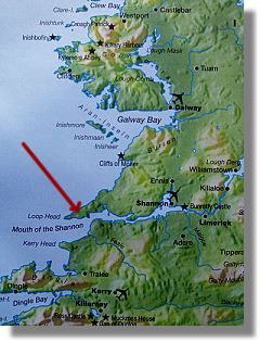
Anvil Farm is located near the tip of the West Clare (Loop Head) penninsula, as shown on the map to the right. It is 16 km from Kilkee town, and 30km from Kilrush town.
Clare is located on the west coast of Ireland. It is a county (Ireland is divided into 32 counties), located directly to the south of Co. Galway, west of Co. Limerick, and north of Co. Kerry.
Directions:
LOCAL: From Kilrush, take Route N67 to Kilkee. Through Kilkee, take the R487 towards Loop Head. Pass through Cross Village, and travel for a further 3 km until the road forks. Anvil Farm is the large house on the V of this fork.
FROM NORTH CLARE (BURREN / CLIFFS OF MOHER AREA) Follow signs to Lahinch, then take the N67 Costal Route to Kilkee, via the towns of Miltown (or Spanish Point), Quilty and Doonbeg. Follow the directions from Kilkee as per LOCAL section above.
FROM KERRY Go to car-ferry at Tarbert (timetables on our 'links' page); ferry brings you to Kilimer, take left turn and travel 10km to Kilrush. Follow directions from Kilrush as per LOCAL section above.
FROM
LIMERICK AND ALL OTHER AREAS Take Route N18 to Ennis and follow signs towards Route N68/Kilrush. Ennis to Kilrush is 44km. Follow directions from Kilrush as per LOCAL section above.
|
 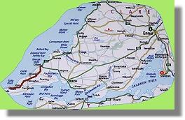
a click on the map opens a window with an enlarged view
|